Surveys & Assessments
Learn what a stone survey is, when it is required, and how architects document masonry conditions for preservation, safety, and compliance with Layer.


Stone surveys are a required part of many preservation, façade, or safety-driven projects involving historic buildings. If your background is in new construction, this may be unfamiliar. The intent of a stone survey is to document how masonry materials have performed over time, not how they were designed or originally built.
This guide explains the purpose of stone surveys, where they are most often required, and how to prepare for this type of work as an architect.
What is a stone survey?
A stone survey is a visual and structured assessment of the condition of stone used in a building façade or structure. The goal is to identify the types of stone present, document how they were installed, evaluate signs of deterioration, and classify existing damage by location and severity.
Mixed masonry on a historic façade. Stone surveys document the materials present and how they have aged.
Unlike traditional as-built documentation, stone surveys focus on how materials have aged over time and whether repairs or monitoring are necessary. The results typically inform repair design, preservation scope, or regulatory compliance.
Stone surveys are frequently required for:
Local safety inspection programs, such as New York City’s FISP (Façade Inspection & Safety Program, formerly Local Law 11), which mandates visual and close-up inspections of buildings over six stories every five years.
Historic preservation approvals, such as those required by local landmarks commissions in cities like Boston, Philadelphia, or Chicago.
Restoration scope development for public buildings, universities, or religious institutions undergoing capital improvement projects.
Documentation prior to adaptive reuse or envelope upgrades on masonry buildings.
The role of the architect in a stone survey is to document, not diagnose. You are not specifying repairs or confirming structural adequacy. Rather, your objective is to capture high-quality data that supports others in making informed decisions.
Topics to clarify with your client
Before conducting a stone survey, you should confirm the scope and expectations with the project lead, owner, or preservation consultant. These factors will shape how you plan the survey, what tools you use, and how much time is required.
Here is a checklist of questions you can lean on for that discussion:
Clarifying these items early will determine whether you are tagging every stone unit, mapping conditions by elevation, or creating a condition index tied to sample areas. This will also inform access requirements, team size, and whether digital survey tools are appropriate.

Brownstone rowhouses in the northeast. Soft sandstones like brownstone often require frequent condition surveys due to their susceptibility to moisture damage.
Where are stone surveys are most common?
Stone surveys are common in cities and regions where traditional stone construction was widely used and where long-term maintenance or historic preservation is a factor. If you’re practicing in residential architecture in Houston, you may never need to think about documenting stone condition because most buildings are stick built. If you work in New York City, you might see signs of a facade inspection on an almost daily basis in contrast.
The table below compares how local climate, building age, and regulatory environment shape the need for stone surveys in North America.
City or Region | Historic Construction Type | Common Stone Materials | Why Stone Surveys Are Common |
|---|---|---|---|
New York City | Load-bearing and veneer façades on pre-war buildings | Limestone, brownstone, granite | Required by FISP law for buildings over 6 stories |
Boston | Traditional masonry with frequent freeze-thaw cycles | Granite, sandstone, brownstone | Historic districts and preservation review processes |
Chicago | Heavy masonry in early 20th century high-rises | Limestone, granite, terra cotta | Aging façades in severe climate; local ordinances |
Philadelphia | Colonial and early industrial masonry | Schist, brick with stone trim | Landmark oversight; aging institutional buildings |
Washington, DC | Civic and institutional stone buildings | Limestone, marble, granite | High concentration of historic public structures |
Baltimore | Rowhouses and public buildings | Sandstone, brick with stone | Widespread stone detailing in early neighborhoods |
San Francisco | Stone accents on seismic-retrofitted buildings | Granite, sandstone | Preservation boards; seismic work often triggers review |
Houston, Phoenix, Orlando | Primarily modern framed construction | Limited exterior stone use | Stone surveys are rare due to climate and building type |
In general, stone surveys are most relevant in northern or coastal cities where masonry buildings are older, exposed to moisture and freeze-thaw conditions, and subject to regulatory oversight.
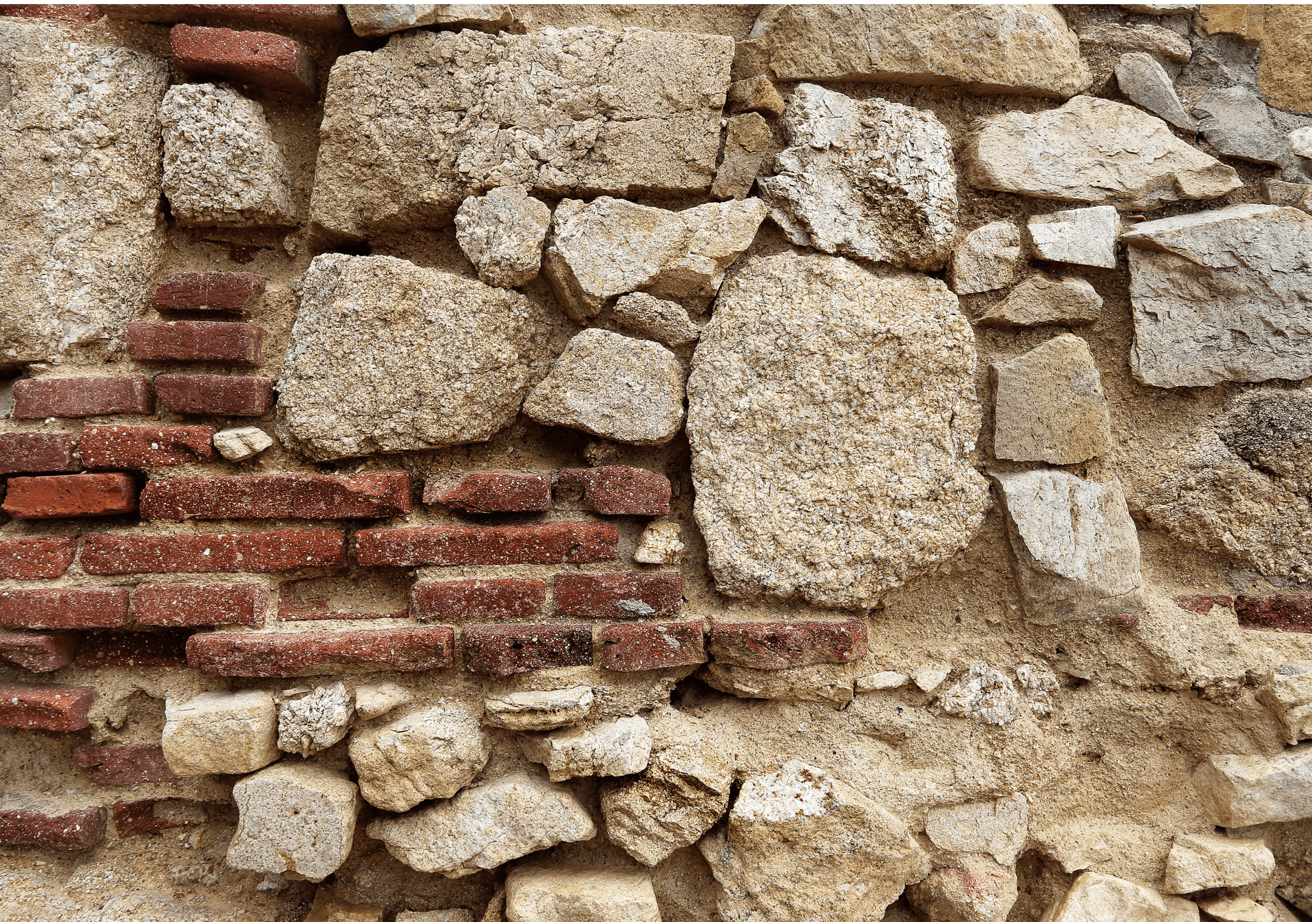
Common stone types in historic construction

A combined brick and granite façade. Transitions between materials are common locations for condition issues.
Architects are not expected to identify the exact mineral composition or origin of stone materials. However, being able to recognize general stone types and their behavior is essential to documenting existing conditions and supporting repair planning.
Stone Type | Typical Use | Common Issues | Notes |
|---|---|---|---|
Granite | Civic buildings, foundations, stoops, water tables | Joint failure, cracking, staining | Durable stone often paired with softer mortar. Staining may result from metal anchors or atmospheric pollutants. |
Limestone | Institutional façades, monuments, masonry veneer | Surface erosion, sugar decay, acid damage | Susceptible to uneven weathering and black crust formation in urban environments. Sensitivity varies by grain and finish. |
Brownstone | Rowhouses and walk-ups in northeastern U.S. | Spalling, delamination, large-scale erosion | Soft, layered sandstone that retains moisture. Frequently patched or consolidated due to maintenance challenges. |
Sandstone | Regional use in civic, religious, and residential buildings | Granular loss, erosion at corners, differential weathering | Varies widely in durability. Documentation should note differences in bedding orientation and finish. |
Marble | Ornament, base courses, monuments | Staining, bowing, surface dissolution | Rare on full façades. Sensitive to humidity and acid rain. Bowing may occur in thin panels. |
Always note transitions between stone types and identify areas with visible replacement or past repair. This is especially important for stone units that have been patched, substituted, or resurfaced.
Conditions to record
A stone survey documents visible deterioration. Your responsibility is to describe what is present; not to explain why it occurred or how to fix it. Use consistent terminology and include location-specific notes to support follow-up analysis.
Condition | Description |
|---|---|
Cracking | Linear breaks in the stone or at mortar joints. May include surface hairline cracks, through-body fractures, or stepped cracking related to movement. Record orientation, length, and depth if observable. |
Spalling | Loss of stone material from the surface, often exposing coarse texture or aggregate. Typically caused by freeze-thaw cycles, moisture, or embedded metals. |
Scaling | Superficial flaking or exfoliation of the stone face. May signal early-stage deterioration or precede deeper loss like spalling. |
Delamination | Separation of stone layers along natural bedding planes or weak lamination. Often found in brownstone or sandstone. May appear blistered or hollow. |
Efflorescence | White or gray crystalline deposits of salts. Indicates active or past moisture movement. Often seasonal or related to drying patterns. |
Biological growth | Presence of moss, lichen, algae, or mold. Most often appears in shaded or damp areas. May retain moisture and obscure underlying conditions. |
Joint failure | Mortar that is cracked, recessed, missing, or deteriorated. Joint failure accelerates water ingress and stone deterioration. |
Displacement | Stone units that are out of plane, bulging, rotated, or otherwise shifted. Can suggest movement, settlement, or anchorage failure. |
Past repairs | Includes Dutchman inserts, epoxy fills, mechanical pins, or patching compounds. Note material compatibility, color match, and condition. |
Incompatible materials | Use of cement-based mortars or rigid sealants that are harder than the surrounding stone or historic mortar. May cause adjacent failure or staining. |
Each condition should be mapped by location and tied to a consistent code or legend. Avoid speculative descriptions. When in doubt, photograph and annotate rather than interpret.
Why mapping is critical
While photographs record appearance, maps communicate location, frequency, and severity. A comprehensive stone survey creates a shared reference for all project stakeholders and allows condition trends to be analyzed across elevations.
Effective survey mapping includes:
Elevation drawings or façade photos to serve as a base
A standard set of condition symbols or color-coded tags
Linked annotations for severity, location, and repair history
A numbering or ID system for traceability
Cross-referenced photographs tied to mapped tags
Mapping supports coordination between design teams, preservation reviewers, and contractors. It also allows for phased repair documentation and comparative analysis across time if follow-up surveys are conducted.
Access considerations
The method you use to inspect a building directly affects how much can be documented and how accurate your observations will be. Before determining how to access a façade or roofline, confirm whether there are specific regulatory requirements or inspection protocols that apply to the project.
Start by identifying:
Whether physical access is required by a governing body
Whether certain façade zones must be observed at close range
Whether you are permitted to conduct visual-only surveys
Whether photography alone will meet documentation standards
Once the requirements are clear, determine what access is practical and permitted based on building height, site conditions, schedule, and safety.
Access Method | Use Case |
|---|---|
Visual survey from grade | Suitable for low-rise buildings or for ground-floor and setback façades. Often used when access is restricted or when only representative conditions are being collected. |
Binocular or zoom-assisted survey | Common for preliminary assessments or when full elevation coverage is not required. Conducted from sidewalks, terraces, or rooftops. Provides moderate visibility but may miss fine-grain deterioration. |
Lift or boom access | Required for close-range inspection or when regulations mandate physical access. Enables touch-level examination of cracks, joints, or repairs. Confirm safety procedures, lift permits, and anchor points ahead of time. |
Drone photography | Best used for general documentation and to capture hard-to-access elevations. Valuable for mapping and coordination but should not be used to classify material conditions unless paired with physical inspection. |
Access planning affects time on site, staffing, and equipment needs. Confirm with the owner or consultant what level of access is expected and what documentation standards must be met before mobilizing.
Digital documentation methods
Mobile documentation platforms reduce time spent on annotation and help maintain consistency across large surveys. Teams using Layer often standardize stone condition surveys using the following workflow:
Upload annotated PDFs, façade drawings, or elevation photos as a base layer
Create structured fields for condition type, severity, and notes
Tag each condition location directly on the drawing
Attach reference photos, detailed notes, or comments to each tag
Export survey data to a report format or sync to Revit if applicable
This method ensures that all documentation is tied to specific geometry, minimizes manual data entry, and supports collaboration with consultants or regulatory reviewers.


